Blog by Adam Clapton.
In 2021, ULAS excavated 96 trenches on land north of Quorn in Leicestershire ahead of proposed development of the site which sits on the floor of the Soar valley, immediately west of the river’s current course. The evaluative work highlighted the presence of archaeological deposits across the site with finds dating to the Middle to Late Iron Age and the Early Roman period. In 2022 and 2023 ULAS returned to undertake an excavation across two areas of the site, a large area in the north (Area 1) and a smaller area to the south-east (Area 6).

The analysis of the finds and environmental samples are ongoing and, in this blog, Site Director Adam Clapton describes the excavations and offers some initial interpretations of the site!
Area 1
The earliest recorded activity in the area was a single small pit of likely Early Bronze Age date. This, along with residual flint from later features, suggests some activity during this period in the immediate landscape. This was likely associated with a known ‘Ring Ditch’ or ‘Barrow’ monument located immediately east of Area 1, which was previously identified by cropmarks and topographical analysis.
In the mid-late Iron Age, a pair of sub-circular livestock enclosures were constructed in the west of the area, with associated pits and postholes to the south. The enclosures had internal diameters of 13-16m with large entrances at their south and east. Pottery included Iron Age scored ware. Other linear ditches were recorded to the north and south, establishing that this was part of an agricultural landscape which extended beyond the excavation limits.
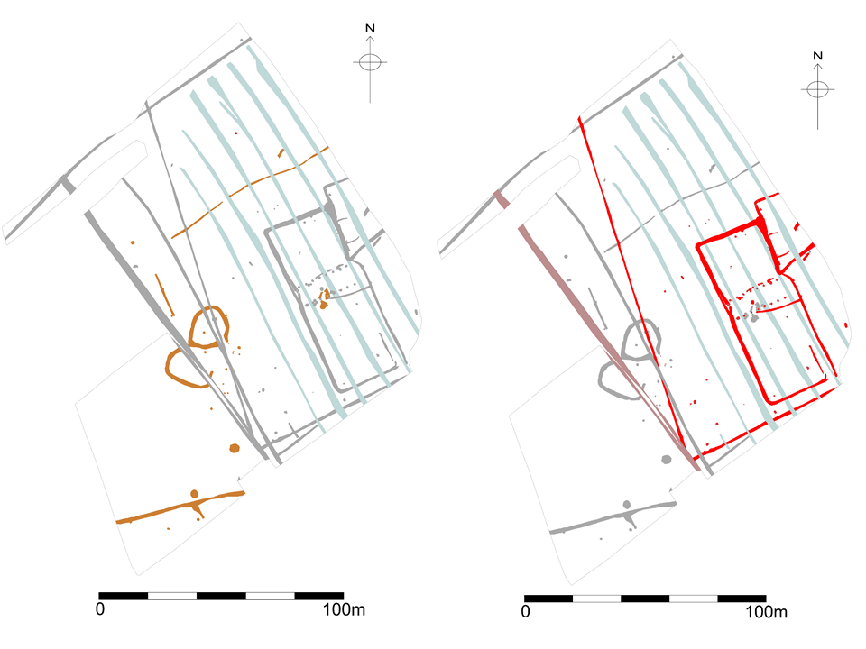
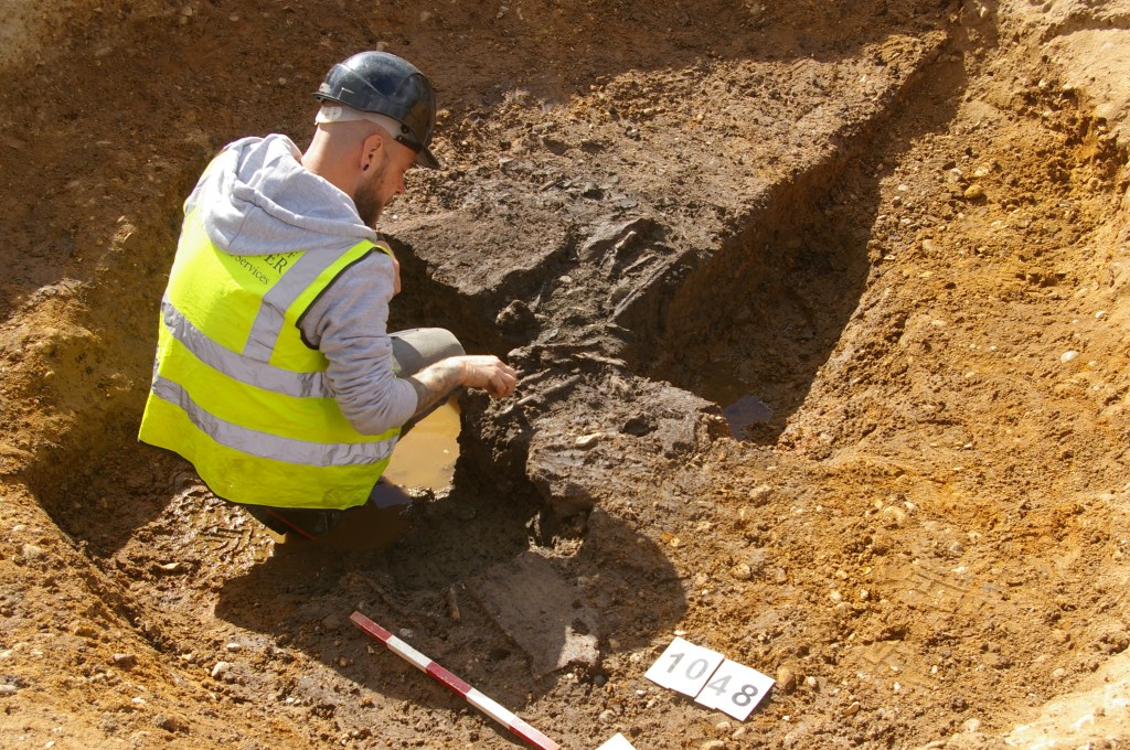
The Iron Age activity was not just represented by ditched enclosures. A pair of large pits, likely represented waterholes, allowed livestock access to water. These were sub-circular in plan, measuring 4m in diameter and up to 0.9m in depth, with moderate-steep sloping sides and flat bases. Due to the waterlogged nature of fills near the bases of each pit, some timber fragments were recovered along with fragments of animal bone. Environmental samples were also taken with the finds currently undergoing specialist analysis. Elsewhere, in the east of the area, two pit groups were recorded made of several intercutting pits, likely dug over a relatively short period of time and representing ad hoc quarrying of the sand and gravels in the area.
In the 1st century AD, a new Roman agricultural landscape was established in Area 1 with pottery evidence suggesting occupation continued throughout the 2nd century. The absence of Roman material from the backfills of the Iron Age features also suggests that they had been entirely infilled by this point.
In the 1st century a sub-rectilinear enclosure was established on the eastern edge of the excavation. This appeared to have an internal secondary enclosure, likely used for livestock control. A larger multi-phased rectangular enclosure was also constructed to its west, likely at the same time, whilst to the south and west further ditches were recorded, which appeared to form part of a much larger enclosed landscape extending beyond the excavation area. The southern most of these created a ‘droveway’ next to the rectilinear enclosure, likely for controlling livestock movements in and out of it.
A scattering of contemporary pits were recorded, including two probable corn dryers which would have been used for processing crops on the site. These were sub-oval in plan, measuring 2m in length, 0.9m in width and up to 0.25m in depth, with shallow sloping sides and flat bases. Scorching of the natural gravel substrata was noted at the base of one corn dryer, indicating high levels of heat were produced by its function.
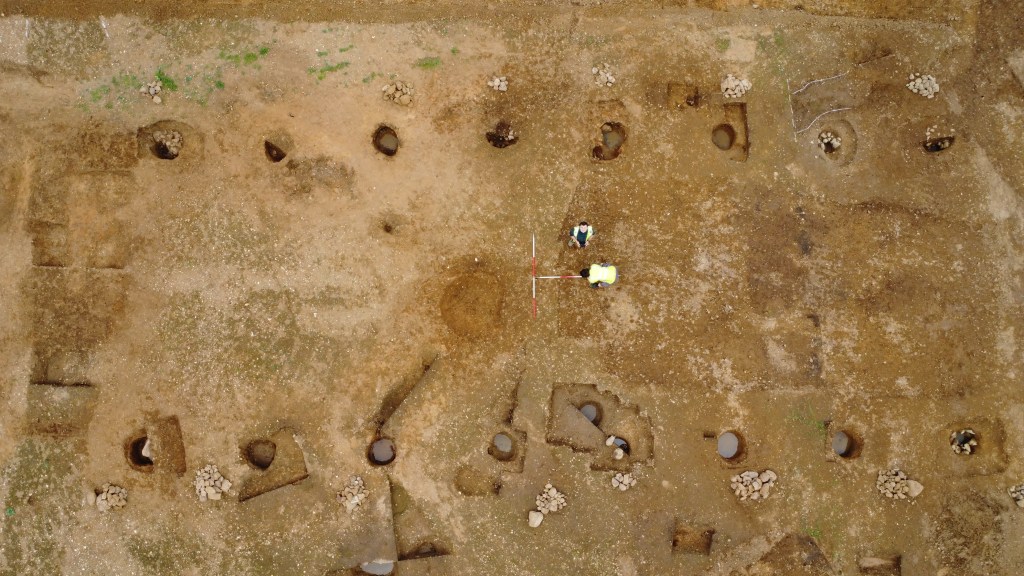
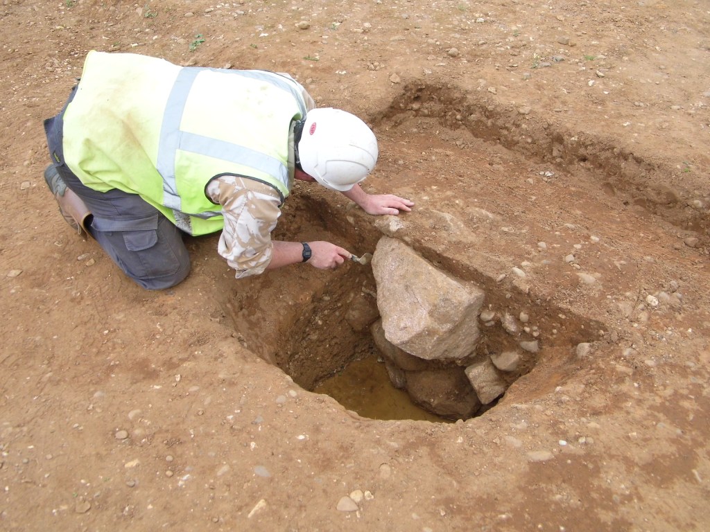
In the 2nd century, the large rectilinear enclosure was redug, including a re-modelling of its entrance at its south-east corner, and a large post-built barn was constructed within it. The Barn was located centrally within the enclosure. It consisted of sixteen large postholes, eight on each side, forming the rectilinear structure. Based on the positions of the postholes, internally the building measured approximately 20.5m in length and 7.5m in width on a north-east to south-west alignment. The postholes were spaced between 1.6m and 2.3m apart and collectively, measured between 0.6-1.7m in diameter and up to 0.7m in depth. Many still contained large granite, mudstone and limestone packing stones. In addition, nine of the postholes also contained evidence of post-pipes suggesting the timbers had likely rotted in situ, and the partial remains of an oak timber post was recovered from the base of one of the postholes.
The 2nd century appeared to represent the last phase of activity in Area 1 prior to the establishment of later medieval agricultural activity (ridge and furrow). The absence of Late Roman pottery suggests the landscape was largely abandoned by this point, with activity likely moving elsewhere within the landscape.
Area 6
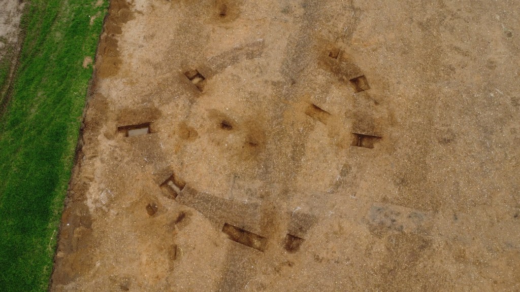
The second area of excavation (Area 6), to the south-east of Area 1, contained a ‘D’ shaped enclosure which was dug in the late Iron Age probably as a livestock enclosure. It had a near continuous ditch, straight on its northern side and curving heading south. A 3.5m wide entrance was located at its south-east arc and internally the enclosure measured 39m by 33m, covering an internal area of 0.12 ha. The enclosure ditch was up to 2m wide and 0.6m deep and had a V-shaped profile. Several other contemporary ditches were also recorded, and extended beyond the excavated area, suggesting continuation of the agricultural landscape beyond. The absence of finds from these features suggested the focus of settlement activity was away from the excavation area.
Look out for Blog 2 which will detail the analysis of the finds and environmental evidence and look at the site in its wider context.
