The many earthworks in Bouskell Park in Blaby have long intrigued visitors. Some are easily interpretable as the remains of medieval ploughing (ridge and furrow) but others, large raised platforms and terraces, linear banks and hollows are more difficult to understand. Are they a lost part of the medieval village of Blaby? Are they the site of the original medieval manor house? Or are they part of the post-medieval gardens and landscaped grounds of Blaby Hall? All three ideas have been presented as possible interpretations in the past.
In 2020, Blaby District Council successfully secured funds from the National Lottery Heritage Fund to deliver the Buried Bouskell project, a community archaeological dig which aimed to explore in more detail the history of the park and to restore an existing Ice House which dated back to 1843. The project was carried out in 2020-21 in partnership with University of Leicester Archaeological Services (ULAS).
The aim of the community project was for residents of Blaby and its wider area to carry out archaeological excavations (test pits) in the park in order to make new discoveries about the past use of the area. It was hoped that this would also inspire and stimulate wider interest in the history of the village and contribute to ongoing academic research into the development of settlement, landscape, and demography in Britain.
Download the full excavation report here (pdf, 20.3mb)

What is Bouskell Park?
Bouskell Park is a 5 hectare public park on the east side of Blaby, a village in Leicestershire just south of Leicester. The park was bought by Blaby District Council from the Bouskells, a family of prominent Leicester solicitors, in the 1990s as open space for the people of Blaby. The landscape you see today, however, is much older and worked flints and Roman and medieval pottery found in the park show that people have been using this area for over 6,000 years.
The parkland was once the private pleasure ground for Blaby Hall which still stands to the north of the park, and it still retains much of its original Victorian character. The pleasure ground was the work of John Clarke who demolished the ‘old hall’, an early 18th-century building, in 1837 and built the Jacobean style house you can see today. Clarke set his new mansion within expansive landscaped grounds with formal gardens close to the hall and to the south (Bouskell Park) informal parkland incorporating tree plantations, a fishpond, an icehouse and a woodland walk (the Long Walk) which projected into the farmland to the east of the park.

If you want to find out more about the history and archaeology of the park check out this self-guided circular walk around the park.

Buried Bouskell Self-Guided Circular Walk
Walk length: 0.5 miles / 0.8 km
The Community Dig
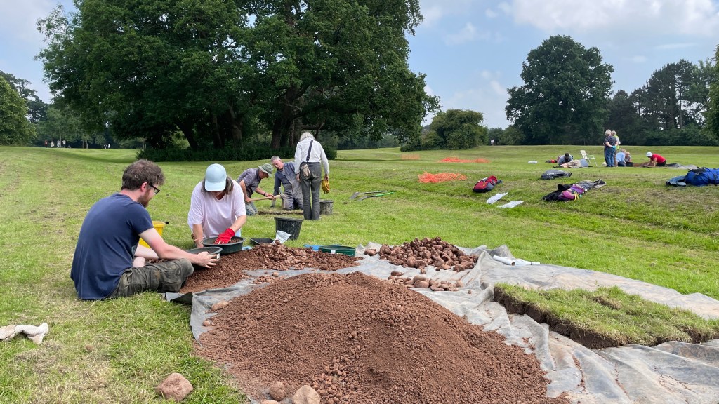
In total, 22 test pits were excavated by more than 130 volunteers and local school children over 7 days in June/July 2021 to investigate various large rectangular enclosures and terraces, linear banks and hollows present in the park. On average, test pits were dug 0.5m deep with 10 cubic meters of soil (approximately 15 tonnes) dug and processed during the course of the excavation.
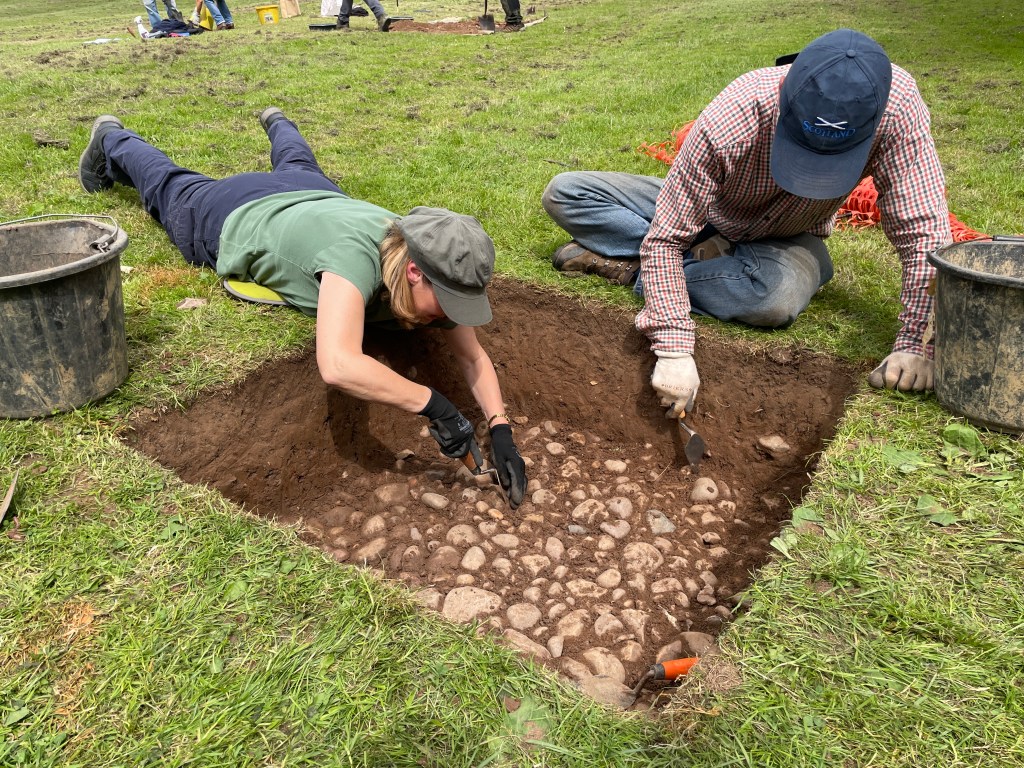
Archaeological features were found in six test pits whilst others were dug through a sequence of topsoil and subsoil to the glacigenic clay. In most areas, ground was found to be reworked in the past, most likely through a combination of agricultural and industrial disturbances (i.e. ploughing, gardening and quarrying) as well as landscape gardening. This was evident in the assemblage of finds of mixed date spread though the soil in most test pits. Archaeological features included medieval cobbled surfaces and a possible wall, post-medieval quarrying and a cobbled trackway, and a 19th-century land drain.
Nearly 2000 individual finds were recovered with archaeological material ranging in date from the Mesolithic period to the present day, including worked flint, pottery, clay tobacco pipe, glass, metalwork, coins, building material, industrial residues, animal bone, and other finds including modern plastic. Most of the pottery (86%) was of 12th – 14th century date with small assemblages of Roman (2%), Saxo-Norman (2%), late medieval (<1%), post-medieval (2%) and modern (8%) pottery also present.

A new understanding of the park
Thanks to the hard work of our volunteers, the Buried Bouskell project has successfully revealed past use of the park area by people dating back over 6,000 years and has started to provide some understanding of the complex landscape of ‘humps’ and ‘bumps’ within the park. Previous interpretations of these earthworks have now been explored and a new narrative for the park’s history can be presented.
Presently, there is no evidence that the archaeology in Bouskell Park represents the original late 9th century settlement of Blaby or the site of the medieval manor house. Instead, from at least the Roman period through to the 12th century the park was under arable cultivation. The earthworks appear to form a row of medieval enclosures, probably the remains of tofts (cottages) and crofts (gardens and paddocks), superimposed over the ridge and furrow of earlier arable fields. These would have fronted on to the road to the west of the park with open arable fields to the east. They represent expansion of the village in the 13th and 14th centuries away from its historic core to the north of the parish church. At present, activity in the different enclosures remains unclear but cobbled surfaces, possible stone walls and ‘midden’ areas (rubbish heaps) represent backyard activities alongside pastoral and arable agriculture.

Settlement in the park appears to have been deserted by the end of the 14th century and from the 15th century onwards the land was given over to permanent pasture. This is typical of many rural settlements in Leicestershire in the 14th and 15th centuries, where farmsteads and areas of village were abandoned. This is often connected to demographic decline in rural communities triggered by a succession of famines and plagues in the 14th century. Abandoned settlement sites like this were rarely repopulated because landowners found it more profitable to devote their land to animal husbandry rather than find new tenants.
In the post-medieval period, the lower central part of the park was quarried, probably a clay pit for local brick production. This was filled in before the park was landscaped as a Victorian pleasure ground in the mid-19th century. This landscaped park was used for recreation by the owners of Blaby Hall and a Victorian lead shot found in one test pit is evidence of game shooting. More recent finds, mostly glass and plastic, represent current use of the park as public recreational space.


Download the full excavation report here
pdf (20.3mb)
Acknowledgements
A project like this could not have succeeded without the support and contributions of many individuals and organisations. University of Leicester Archaeological Services (ULAS) would like to take this opportunity to thank everyone involved, our partners Blaby District Council, particularly Gemma Tallis, Zoe Coulson and Phillip Turner, and the National Lottery Heritage Fund without whom this project could not have taken place.
Funding was provided by the National Lottery Heritage Fund and the School of Archaeology and Ancient History, University of Leicester provided the equipment.
We would also like to thank all the volunteers who contributed to the project, digging and recording test-pits, and collecting and processing finds:
29th – 30th June: Bev Arnold, Neil Bevan, Paul Burgess, Dawn Bolland, Rob Bolland, Carol Cambers, Josh Cattermole, Ralph Coleman, Ann Cope, Simon Dodd, Carl Duckett, Tori Haines, Stephanie Horack, Penny Immins, Aileen Jayes, Jack Lawrence, Paul Lyon, Robbie Mabbett, Mary MacPherson, Robin Matthewman, Dylan Matthias, Fleur Morton, Joanna Morton, Jim Newmark, Tamsin Ordish, Paul Pengelly, Honor Rawlings, Carol Riddington, Gina Sampson, Matthew Sampson, Lesley Sanders, Janice Szewczuk, Chris Tomlinson, Hedley Webber, Virginia Wright.
1st – 2nd July: Judy Arnold, Matthew Bartlett, Phil Boulanger, Tilly Chapman, Robert Cooke, Louise Daniels, Shirley Doughty, Susanne Ellingham, Steve Hubbard, Lynne Johnson, Karolina Kawczynska, Roger Lancaster, Avril Langham, Stephen Leggett, Julia Martin, Jane Mycroft, Catherine Painter, Sally Pearse, Dorian Preece, Nicki Rainbow, Bev Simpson, Keith Simpson, Annette Sivers, Mike Sivers, Kathy Skevington, Dave Statham, Erica Statham, Maxine Stewart, Joy Thompson, Peter Townsend, Jenny Tweddle, Lesley Twedle, Emma Watson, Lois Watson, Rob Watson, Pam Weston, Sue Williamson.
3rd – 4th July: Marion Brandist, Judy Buckell, Claire Chapman, Emily Firth, Harriet Firth, Rachel Firth, Matthew Gamble, Alex Goodger, Emma Harris, Tom Harris, Alex Hartshorn, Paul Hartshorn, Jude Hughes, Glenn James, Thomas Kelly. Dan Knight, Lucas Knight, Leigh Lewis, David Liew, Zoe Lloyd, Trevor Mildred, Tricia Mildred, Ed Orsi, Neely Orsi, Sue Priestnall, Simon Russell, Jean Stannett, Pat Troake, John Troake, Rob Turnball, Maggie Warrington, Gabriel Weir, Jonah Weir, Mathew Weir, Sheena Wilford.
From ULAS, fieldwork was supervised by Mathew Morris with Sofia Picken and Ffion Rogers. Post-excavation analysis at ULAS was undertaken by Mathew Morris and Sofia Picken with specialist assistance from Wayne Jarvis (flint) and Paul Blinkhorn (pottery). Photographs were taken by ULAS staff, Blaby District Council staff and Bill Newsinger. The project was managed for ULAS by Mathew Morris.
