- Location: Bouskell Park, Welford Road, Blaby LE18 4FT
- Walk length: 0.5 miles / 0.8 km
- Gradient: Level and moderate, gravel path
- Parking: Yes, car park accessed from Welford Road
Download a printable version of the walk here (pdf, 1.49mb).
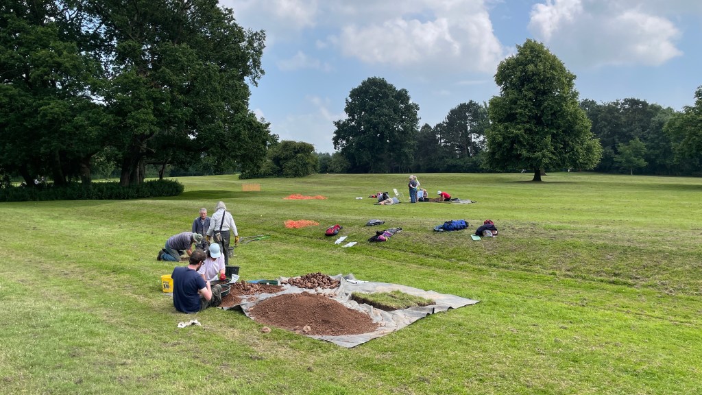
Welcome to Bouskell Park. I’m Mathew Morris from University of Leicester Archaeological Services and I’m the lead archaeologist for Blaby District Council’s Buried Bouskell project. In 2020-21, this project, supported by the National Lottery Heritage Fund, restored the park’s historic icehouse and gave local volunteers and schools a chance to take part in an archaeological dig to explore the park’s history. On this self-guided circular walk, I will take you around the park and tell you what we know so far about its history and archaeology.
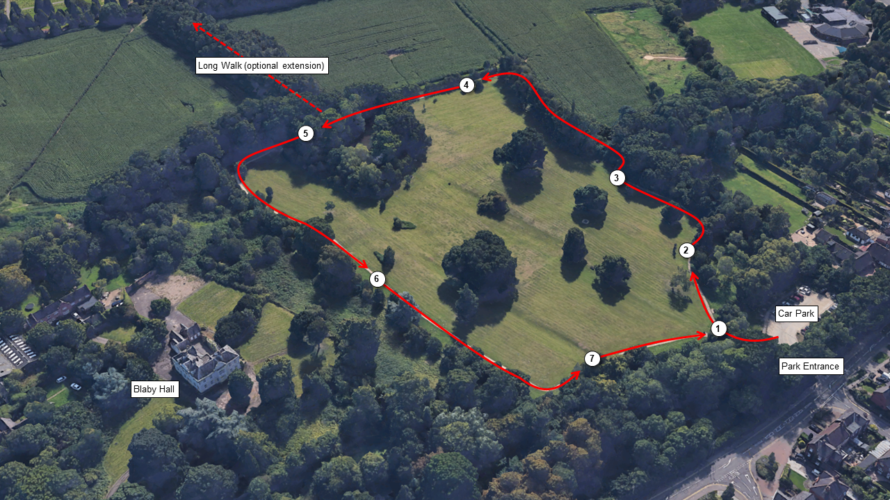
Cross the footbridge from the car park into the park.
1. A Victorian Pleasure Ground
The footbridge crosses an unnamed tributary stream, which rises near Countesthorpe about a mile south of the park and flows north through Blaby into the River Sence near Glen Parva.
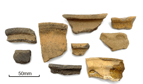
The park was bought by Blaby District Council from the Bouskells, a family of prominent Leicester solicitors, in the 1990s as open space for the people of Blaby. The landscape you see today, however, is much older and worked flints and Roman and medieval pottery found in the park show that people have been using this area for over 6,000 years.
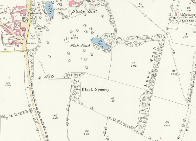
The parkland was once the private pleasure ground for Blaby Hall, which can be seen through the trees to the north, and it still retains much of its original Victorian character. The pleasure ground was the work of John Clarke who demolished the ‘old hall’, an early 18th-century building, in 1837 and built the Jacobean style house you can see today. Clarke set his new mansion within expansive landscaped grounds with formal gardens close to the hall and to the south (Bouskell Park) informal parkland incorporating tree plantations, a fishpond, an icehouse and a woodland walk (the Long Walk) which projected into the farmland to the east of the park. This parkland was meant to be experienced in motion, with visitors walking out to catch glimpses of the different features and the house between the trees. It was also used for recreation and a Victorian lead shot found in the park is evidence of game shooting.

When the path forks, follow the path to the right.
2. A lost medieval village?
The park has many prominent ‘lumps’ and ‘bumps’. These are clearly visible as you walk along the path and they form large rectangular enclosures and terraces, linear banks and hollows which are thought to be a deserted part of the medieval village of Blaby.
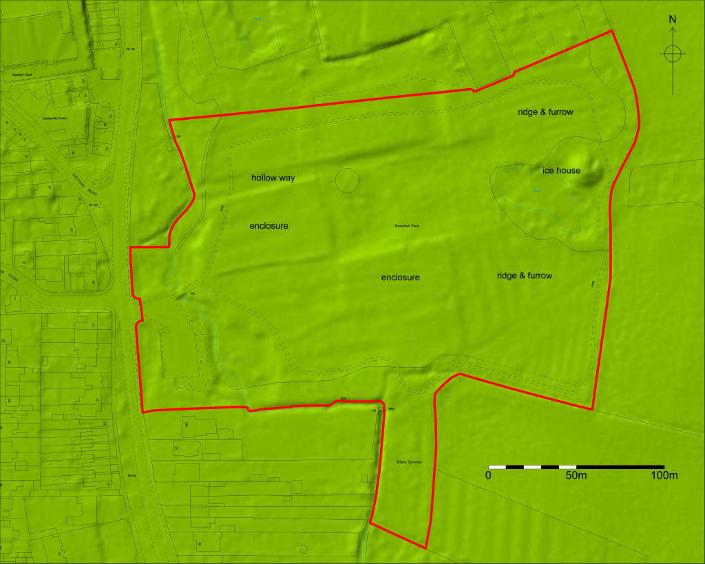
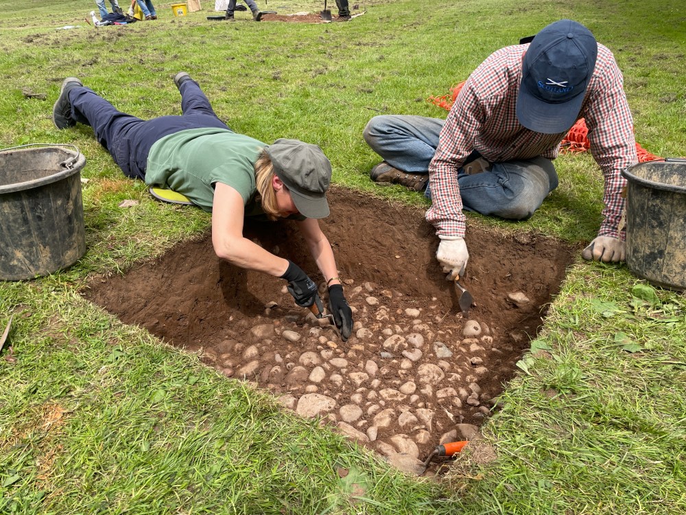
Medieval pottery was found when this path was installed in 1997, as well as cobbled surfaces and a stone wall. The Buried Bouskell project also found cobbled surfaces, possible walls and large quantities of 12th- to 14th-century pottery which was probably dumped in middens (rubbish heaps) and manuring scatters in some of the enclosures.
These discoveries confirm that there was medieval occupation in the park, possibly a row of tofts (cottages) and crofts (plots of land attached to the cottages) established in the 12th or 13th century. These would have fronted on to the road to the west of the park and represent growth of the village away from its historic core around Blaby Green to the north of All Saints Church. Alternatively, the earthworks could be a group of small fields surrounding a farmstead in the south-west corner of the park. Activity in the different enclosures is characteristic of backyard and garden activities as well as arable and pastoral agriculture.
The park was not the site of the original manor house, which was probably where Blaby Hall stands today, and the area was abandoned by the 15th century. This is typical of many rural settlements in Leicestershire in the 14th and 15th centuries, where farmsteads and areas of village were deserted. This is often connected to demographic decline in rural communities triggered by a succession of famines and plagues in the 14th century.
Continue along the path as it heads east.
3. Prehistoric and Roman activity
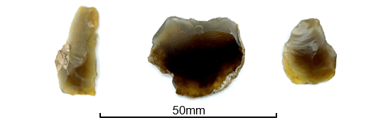
Three worked flints (below) were recovered from test pits dug during the Buried Bouskell project. These are an indication of people using the general environs of park in the Mesolithic (10000—4000 BC) and Bronze Age (2600-700 BC) periods. For much of the time this area was heavily wooded and the flints are chance losses rather than indications of occupation in the park.
A small assemblage of Roman pottery was also recovered from the test pits. This was in poor condition which suggested that it was circulating in the ground for a long time and was likely introduced to the soil through manuring cultivated ground with domestic waste transported from elsewhere. It is unlikely that there is a Roman settlement in the park.
4. The medieval open field
As you reach the east end of the park look carefully at the earthworks. You might be able to see that they form parallel lines. This is the remains of ridge and furrow, created by medieval ploughing. Repeated ploughing would pile earth up into a series of ridges separated by shallow furrows. It marks the beginning of Mill Field, the open field to the east of the village. From the Roman period the whole park was farmland, until in the 12th or 13th century the western half was taken out of arable cultivation and converted into new properties as the village expanded. From the 15th century onwards the park was given over to permanent pasture. Abandoned medieval settlement sites like this were rarely repopulated because landowners found it more profitable to devote their land to animal husbandry rather than find new tenants.
Continue along the path as it turns north.
5. The Icehouse
Hidden in the trees next to the large fishpond is the icehouse. Built in 1843, it is a domed circular brick structure with an arched entrance tunnel buried beneath a clay mound next to the fishpond. It is a fine example of a structure which was once common in the grounds of most country houses from around 1600 until the introduction of mechanical refrigeration systems in the early 20th century.
The interior is nearly 3m in diameter and 3m high. In the winter, servants from the hall would cut ice from the pond and load it into the icehouse through a hole in the top of the dome. Straw would be used both to add additional insulation and to prevent the ice from forming a single large block. The stored ice would then be taken out through the 2m long tunnel on the north-east side of the mound, as needed, to the kitchens to keep perishable foodstuffs cool.
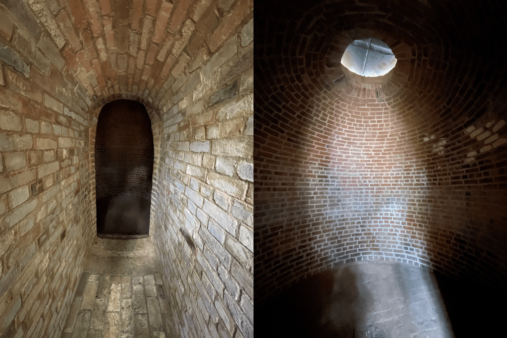

Iced dishes at formal dinners and parties helped demonstrate the owner of Blaby Hall’s status and wealth and a properly maintained icehouse would be capable of storing ice throughout the year. Despite their utilitarian function icehouses were prized structures within the garden landscape and their earth-covered mounds were often clearly visible within the garden. This is the case here, where the icehouse was plainly visible from the hall and visitors would have passed close by as they strolled through the park to the Long Walk.

With the advent of refrigerators, which could be installed directly into the kitchen, icehouses became redundant and fell into decay. At Blaby, the original structure still survives very well. Its entrance was partially restored in the 1990s. Now, it is undergoing further restoration to ensure its long-term preservation.
When you reach the Icehouse, if you want to extend your walk you can divert to the right onto the permissive path along the Victorian ‘Long Walk’, an atmospheric woodland walk, otherwise continue along the path.

6. The manor of Blaby
Through the trees to the right is Blaby Hall, traditionally the home of the lord of the manor but now converted to offices. Blaby, spelt Bladi in 1086, comes from Blábýr, a Scandinavian place name meaning ‘Blár’s farmstead’. Names ending in -by are very common in Leicestershire and indicate settlements established after the Vikings conquered parts of the Anglo-Saxon kingdom of Mercia in the late 9th century AD, in an area which came to be known as the Danelaw.
Following the Norman Conquest in 1066, Blaby’s Anglo-Scandinavian lords, Beorhtmær and Ulf, were ousted and William I granted the manor to one of his closest followers Robert, Count of Meulan, who became the first earl of Leicester in 1107. The village in the late 11th century had 37 households (about 150-200 people altogether). Land in the Sence Valley to the north of the village was meadow whilst on the higher ground to the south were open arable fields. There was also a watermill, probably on the site of the present Blaby Mill to the east of the village.
In the 12th century, the earls of Leicester granted Blaby to the Lodbrookes, who from the 13th century onwards styled themselves ‘de Blaby’. In 1534, the manor passed through marriage to the Savilles and in the late 17th or early 18th century George Saville sold the manor to the Ashby family, who in turn sold it to Thomas Major in 1760.
In 1766 the open fields in the parish were enclosed. The records for this event gives us an amazing window into what the village was like in the mid-18th century, as it began to grow from a small farming community into an industrial settlement (by 1846 the village had 1,150 inhabitants, many employed as framework knitters).
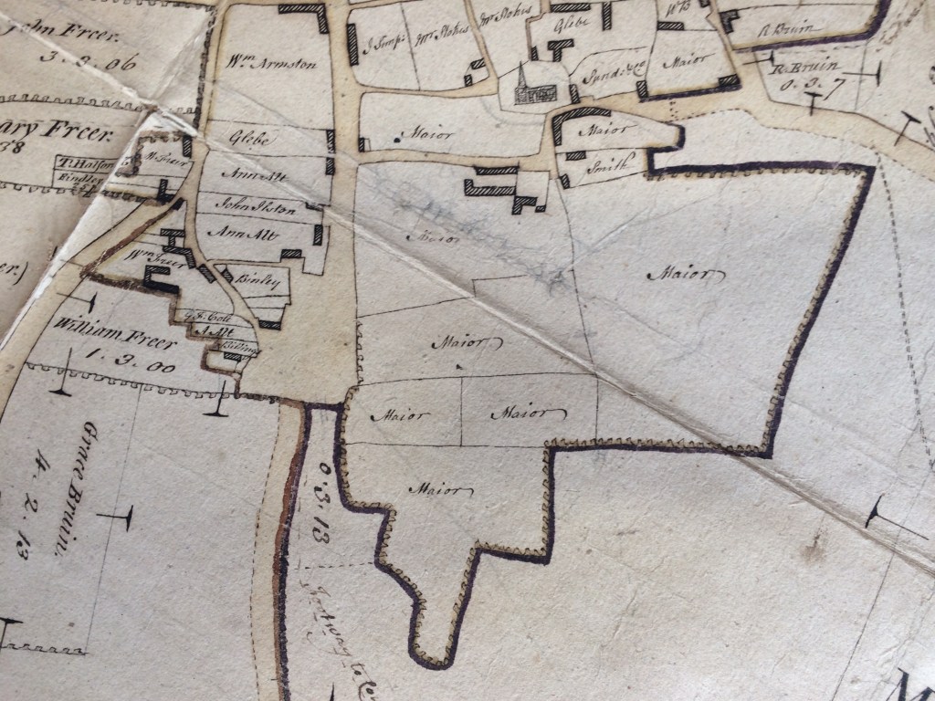
The enclosure map gives a clear indication that the earthworks in the park pre-date the Victorian pleasure ground. The Buried Bouskell project has found that they are relics of medieval settlement dating to the 12th to 14th-century (see Stop 2 above).
Continue along the path back towards the car park.
7. The sunken trackway
As you walk back to the car park you will again see the many earth platforms and enclosures to your left, including a long straight hollow heading from the stream into the park. This is a sunken trackway which probably dates back to the medieval period and carts using it for hundreds of years have eroded the ground away. To the west, the trackway would have forded the stream and connected with the road giving the village access to the open fields. To the east it joins a second sunken trackway heading north past the hall to the church. The Buried Bouskell project found that the trackway was paved with cobbles and was still in use in the late 17th or early 18th century, giving access to the sunken central area of the park which was being quarried to extract clay for local brick production.
Bouskell Park is a fascinating palimpsest which preserves over 6,000 years of changing rural landscape, from forest to open field to medieval village to brick pit to country house garden and landscaped park. I hope you have enjoyed your walk.
If you would like to know more about the Buried Bouskell project and the restoration of the icehouse please click here to find out more about the project and download the excavation report.
Or visit www.visitblaby.org.uk/heritage/bouskell-park-ice-house/
This walk was originally created for the 2020 CBA Festival of Archaeology’s Online and Active programme by University of Leicester Archaeological Services and Blaby District Council and was updated following completion of the project in 2021.