Blog by Gavin Speed.
Loddington Archaeology Fieldschool
This year, students at the University of Leicester’s School of Heritage and Culture (SHAC) had a unique opportunity to gain hands-on experience in archaeological fieldwork as part of their undergraduate degree. Many of these practical skills are developed through SHAC’s immersive fieldschools, expertly run in partnership with the University of Leicester Archaeological Services (ULAS).
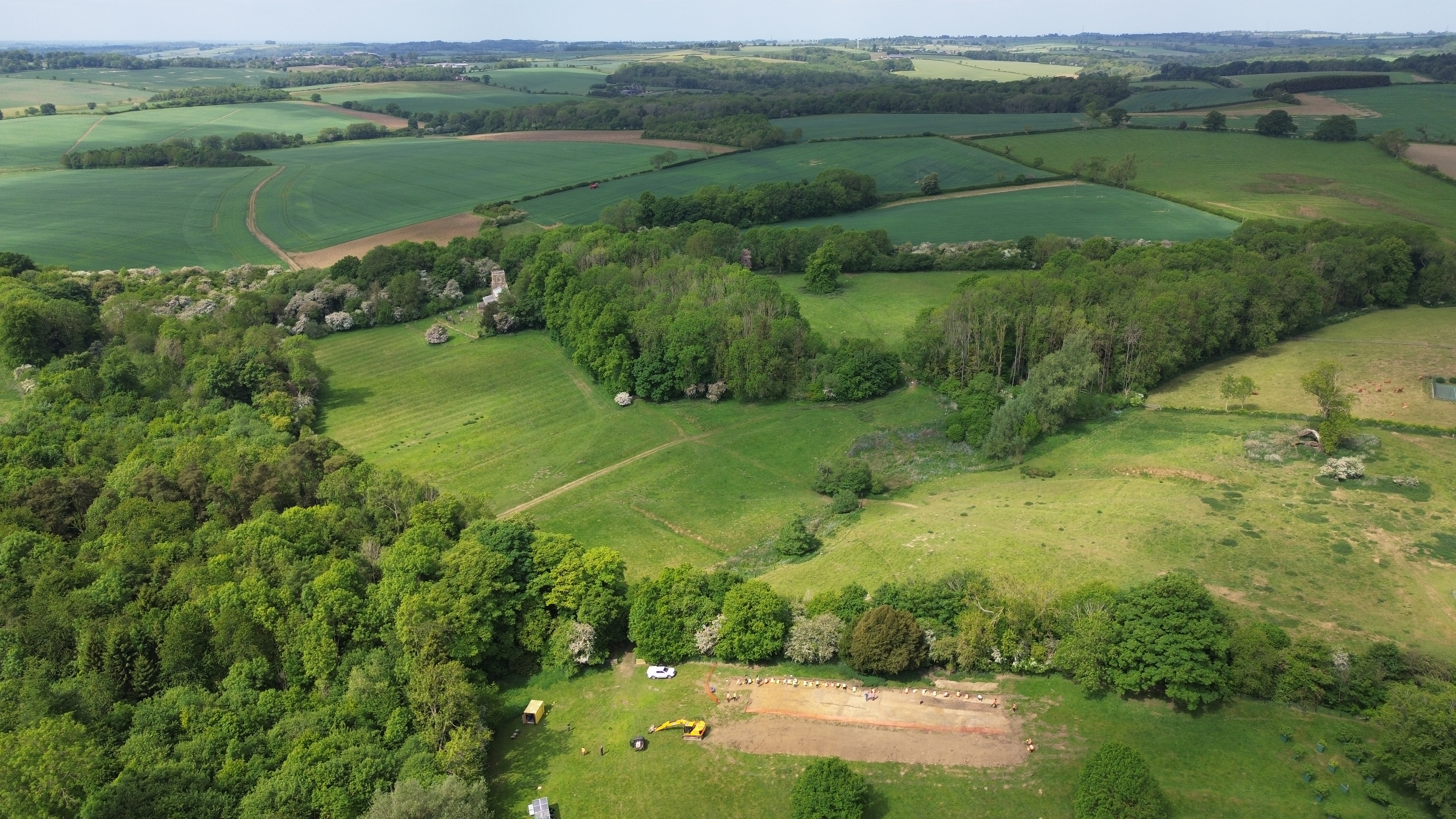
Our latest fieldschool began in May 2025 in the quiet village of Loddington, nestled in east Leicestershire. Though small and seemingly sleepy, Loddington holds a wealth of hidden archaeological secrets waiting to be uncovered.
In this blog, Dr Gavin Speed (Project Manager, ULAS) and Dr Philippa Walton (Fieldschool Director and Lecturer in Roman Archaeology, SHAC), share some of the exciting discoveries made so far—and what lies ahead.
Secluded Village with Ancient Origins
Set in the rolling countryside near the Leicestershire–Rutland border, Loddington is a picturesque village just six miles southwest of Oakham. With its ironstone cottages, grassy verges, and mature trees, the village has a secluded, almost timeless feel.
One of its most striking landmarks is Loddington Hall, a grand 17th-century stone house. Once a hunting lodge in the early 20th century, the Hall later served as accommodation for paratroopers and even an evacuated dance school during World War II. Today, it’s a private residence, set back from the main street and surrounded by parkland that includes 18th-century landscaped lakes.

Another highlight is the village church, St Michael and All Angels. Dating back to the 12th century, it blends Norman and Gothic architecture and sits unusually on the village’s edge, across a meadow framed by woodland—unlike the central placement typical of many English villages.
But Loddington isn’t just scenic—it’s steeped in history. The village name likely dates to the Anglo-Saxon period, derived from the personal name Luda and the Old English ingtūn, meaning “the settlement connected with Luda” (Bourne 2003). First recorded in the Domesday Book of 1086 as Ludintone, the land later passed to Launde Abbey in the 12th century, then to Thomas Cromwell after the Dissolution of the Monasteries, and eventually to the Pretyman and Morris families in the 17th century.
Since 1992, the estate has been home to the Allerton Project, a pioneering initiative by the Game & Wildlife Conservation Trust focused on sustainable farming and conservation. Thanks to their generous support, we’re now able to explore the archaeology of Loddington in greater depth.
Humps and Bumps
The village has a population of around 80 today, but we know in the 18th century there were around 130 inhabitants, and a documentary record from the 14th century tells us that there were perhaps around 200 people living there. There are many ‘humps and bumps’ in the pasture fields surrounding the village that show that it has substantially shrunk in size, once being much larger in the medieval period.
These subtle humps, hollows, and terraces in the landscape were carefully mapped by archaeologist Fred Hartley (Hartley 2018), revealing the hidden story of a once larger village.
One of the most striking features is a sunken track known as a ‘hollow way’, which runs south from the vicarage on Main Street down towards the church. This ancient route—likely medieval in origin—was once flanked by buildings, their former footprints still visible as terraced platforms. These platforms, along with traces of ridge and furrow ploughing and old field boundaries, hint at a thriving settlement that extended well beyond the modern village core.
Near the church, the earthworks become even more complex. A network of tracks and hollow ways once connected houses, outbuildings, and fields. One such track led west to a house still standing in the 1880s, while another curved down to the stream, possibly forming a direct route to the church. Along these paths are the remains of building platforms, closes (enclosed plots), and signs of later land divisions.
Another cluster of earthworks lies within Loddington Hall’s former gardens, a series of garden terraces and long ornamental ponds—one still water-filled—add a post-medieval flourish to the landscape, though some terraces may also mark earlier village buildings.
Together, these earthworks form a ghost map of a village that has shifted, shrunk, and evolved over centuries—but never quite disappeared. For those who know where to look, Loddington’s past is still written in the land.
Untapped Remains
Our initial investigations started with desk-based assessment, which drew together all the available data, such as earlier archaeological investigations and historic maps. Previously, fieldwalking surveys by the Leicestershire Fieldworkers between 2009-2012 found prehistoric worked flint scatters, and concentrations of Roman material in the vicinity of the village, indicating settlement sites.
Within the village, in 2008 a trial-trench evaluation by ULAS at Loddington Hall revealed early Medieval settlement evidence – linear features, pits and areas of stonework. The evaluation also yielded several large sherds of Anglo-Saxon pottery and a small amount of tap slag, maybe suggesting that iron was worked here (Hunt 2008). Archaeological work at the Allerton Research Centre in 2012 also revealed later medieval material, including 13th-14th century pottery and metal finds, including a silver coin.
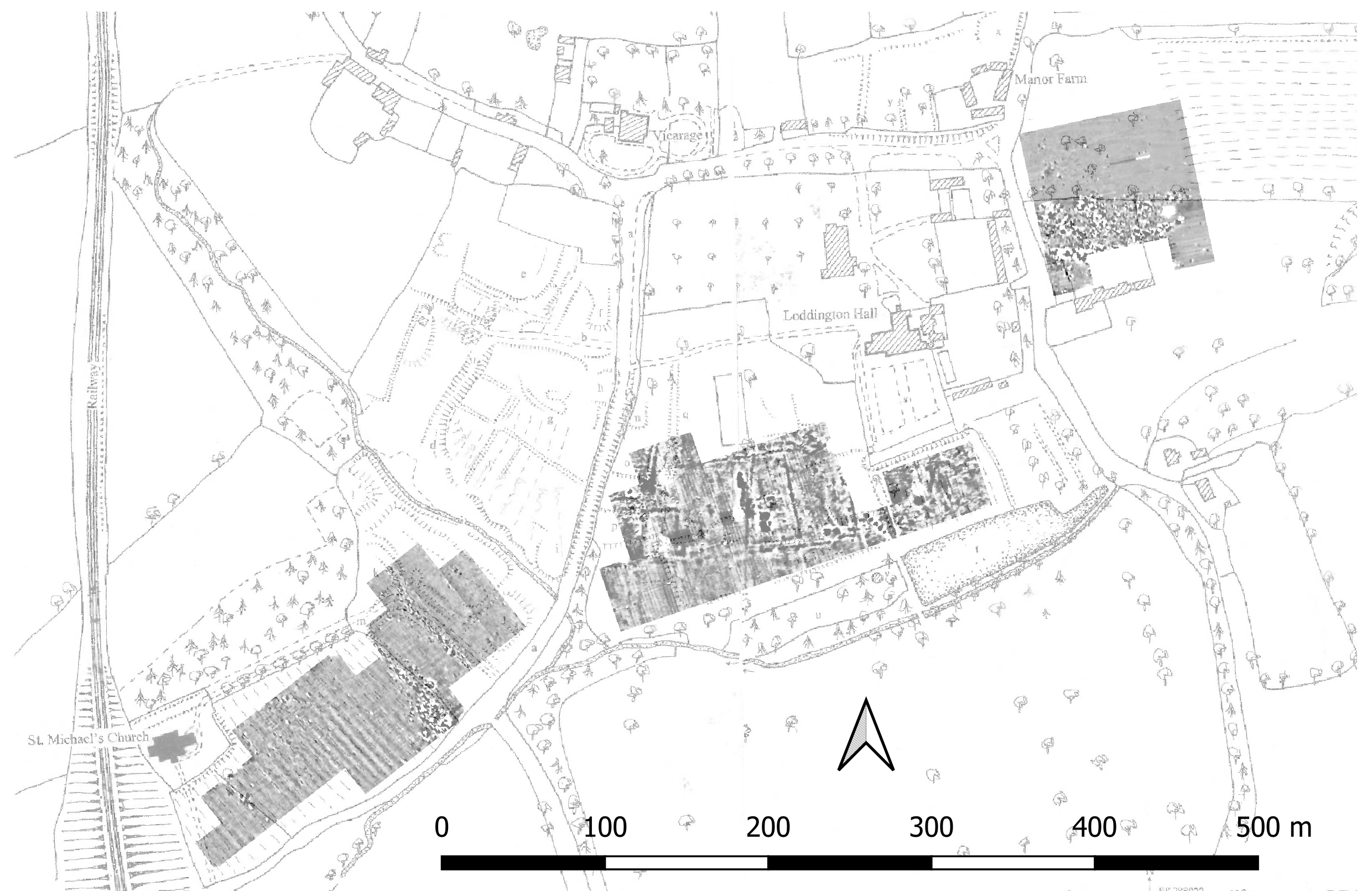
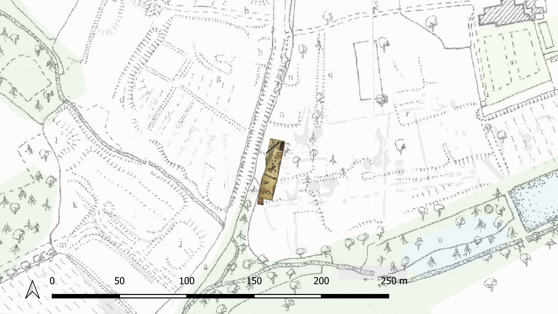
In advance of the Fieldschool, in 2024, a geophysical survey was undertaken over three large areas of the village by a team of local archaeologists from the Leicestershire Fieldworkers. They identified a range of features for us to explore during our Fieldschool excavation. The field to the south of the hall produced the most clearly visible potential archaeological remains, showing many possible archaeological features below the ground.
From the small number of archaeological investigations within and around the village, it was clear there was good survival of archaeological remains, but little had been investigated previously, meaning that any discoveries from our Fieldschool had the potential to add significant new insights and understandings on Loddington’s medieval past.
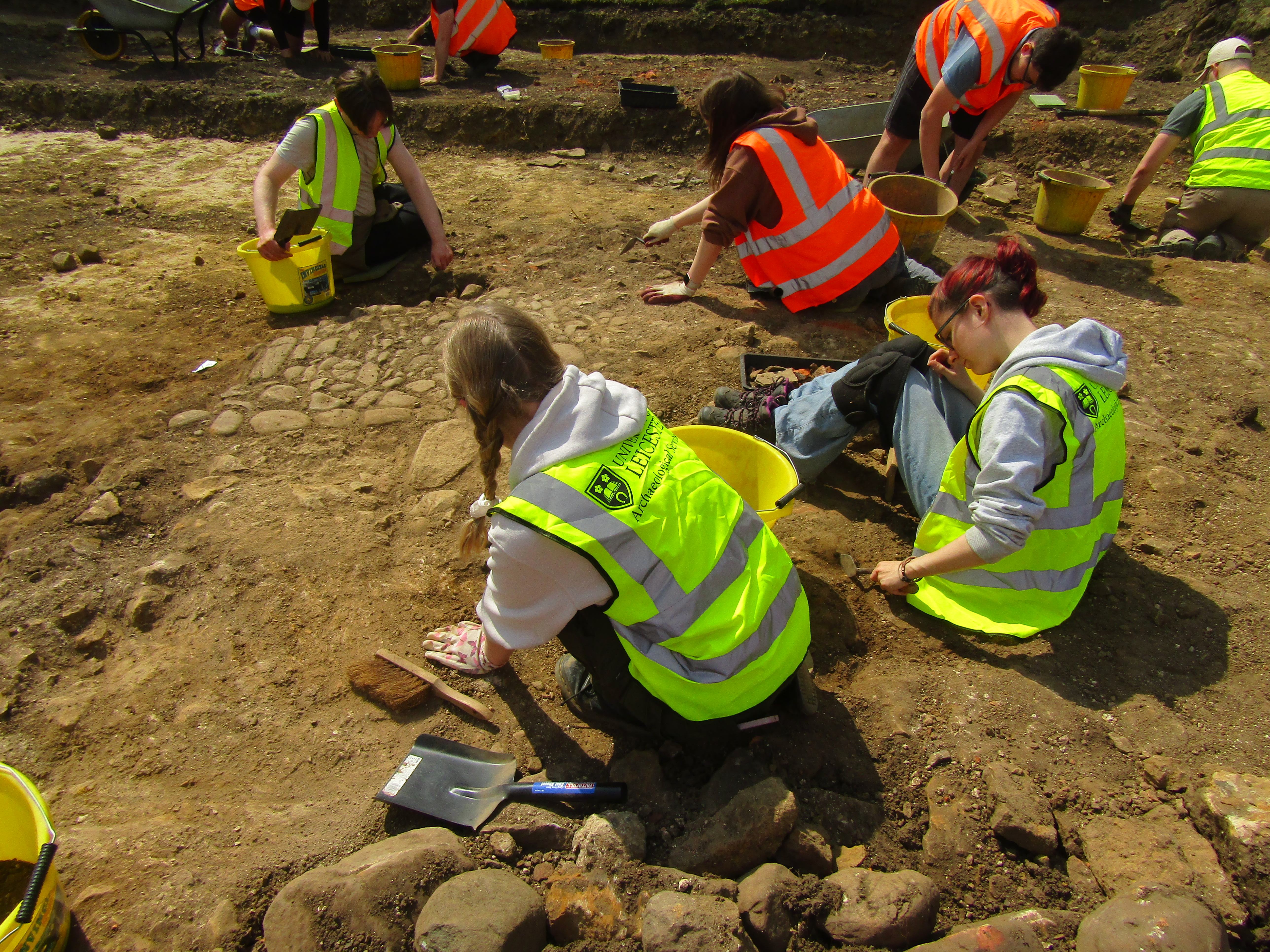
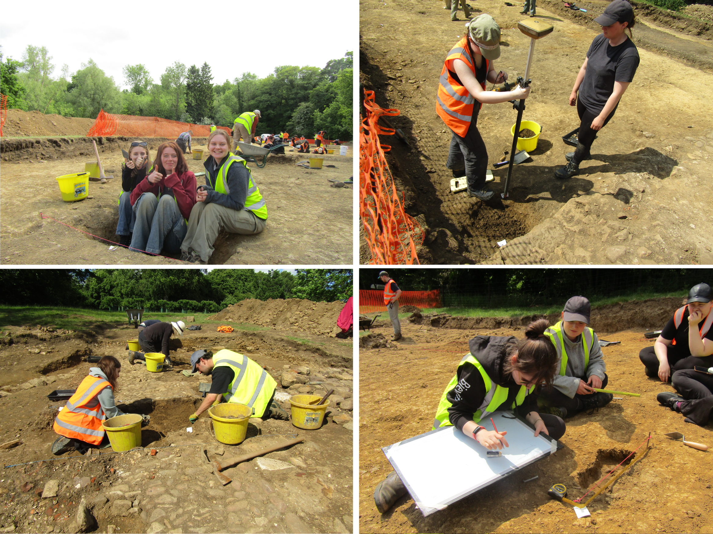
The Dig
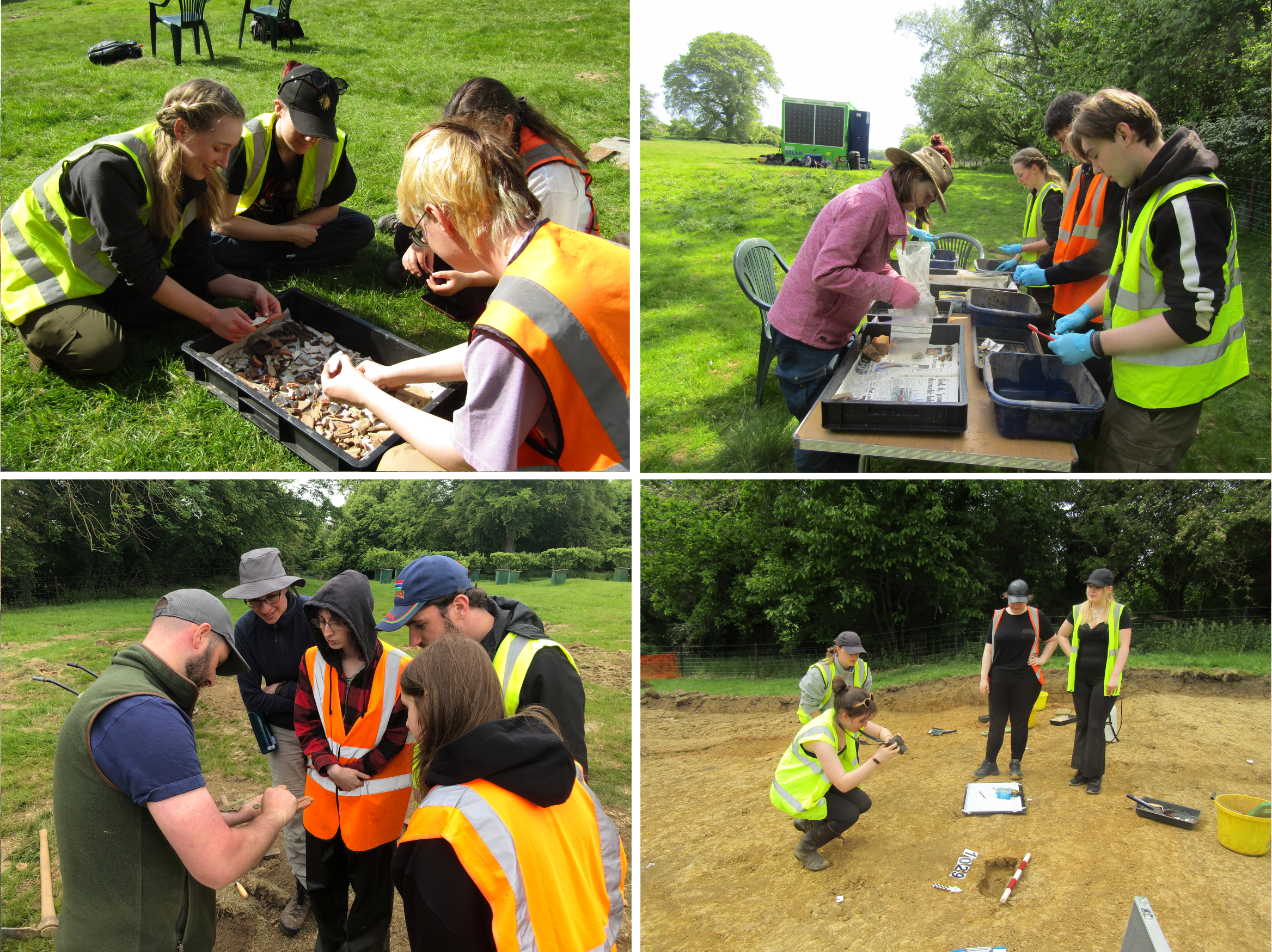
The archaeological training ‘Fieldschool’ provides an opportunity for fieldwork training for undergraduate Archaeology students from the University of Leicester, and crucially enhances the local communities’ understanding of the history of their village. The project aims to assess the nature of any surviving archaeological remains relating to the shrunken medieval village, and to interpret the deposits uncovered. The excavation led by Joe Peters (Supervisor, ULAS) and supported by Harriet Coulton (ULAS), along with various colleagues in the trench from SHAC, and Dani de Carle (Site Technician) leading the management of the finds, samples, and site kit!
The excavation uncovered numerous post-holes forming road-side structures, set within ditched boundaries. Pottery from these features – and nearby pits – included sherds of Stamford Ware, a type of lead-glazed earthenware produced between the ninth and thirteenth centuries. The northern part of the trench contained a later building, with surviving stone walls, tile floors, and a pebbled path, this is likely of post-medieval date.
Student Experiences
As well as learning excavation and recording techniques, the students also enjoyed a range of practical workshops delivered by staff and postgraduates from SHAC. This included sessions on medieval settlement, villages within the wider medieval landscape, maps, medieval ceramics, careers in archaeology, social media, RTI scanning, and archiving.
The three words most commonly used by the students to describe the fieldwork experience, were overwhelmingly positive and reflective of both the challenges and rewards of the process. Students described it as fun, interesting, and informative, while also highlighting qualities such as engaging, educational, and rewarding. Other descriptors included challenging, exciting, enjoyable, and memorable, with some emphasizing the practical and exploratory nature of the work. Overall, the responses convey a sense of enthusiasm, personal growth, and the unique, hands-on learning opportunities that the fieldwork provided.
Students most enjoyed the hands-on aspects of the Fieldschool, particularly excavating, digging, and discovering artefacts, as well as the opportunity to develop practical skills and learn through experience. Many appreciated the balance between workshops and fieldwork, finding the sessions—especially those on careers—informative and insightful. The supportive and friendly team, including supervisors and staff, was frequently praised for creating a comfortable and engaging environment. Social elements such as working with friends, chatting on site, and being part of a collaborative team also stood out as highlights, alongside the excitement of interpreting features and seeing progress over time.

The Fieldschool will continue for the next cohort of archaeology students in 2026 and we will keep you updated through our social media accounts!
Acknowledgements
Thanks to the Allerton Project, for allowing us to dig a big hole in your field, and for the use of your fab resources at the Allerton Centre, and particularly to Jobe Burnham for his help throughout.
Thanks also to colleagues for helping teach in the trench and / or for delivering the practical workshops: Alice Sampson, Ben Donnelly-Symes, Ben Jervis, Ben Morton, Carmen Ting, Debbie Frearson, Dawid Sych, Janie Masseglia, Jo Appleby, Janie Masseglia, Neil Bevan, Nichole Sheldrick, Nick Cooper, Huw Barton, Pete Liddle, and Stefan Cabaniuk. Thanks also to the Leicestershire County Council Planning Archaeologists (Richard, Chloe, and William) and Helen Wells (Senior Historic Environment Record Officer) for visiting and giving the students an insight into career opportunities in curatorial archaeology. It was also fantastic to see so many local residents visit us throughout the dig, and the 100s who came to visit us during our open day ‘trench tours’.
Join Us!
If you’re interested in joining us on a future Fieldschool, have a look into studying archaeology, ancient history, or museum studies at the University of Leicester’s School of Heritage and Culture https://le.ac.uk/heritage-and-culture
References
Bourne, J (2003), Understanding Leicestershire & Rutland Place Names. https://www.hoap.co.uk/ul&rpn.pdf
Hartley R F (2018), The Medieval Earthworks of South and South-East Leicestershire. Leicestershire Fieldworkers. Monograph No. 4. https://leicsfieldworkers.org/about-us/publications/
Hunt, L (2008). An Archaeological Field Evaluation on land at Loddington Hall, Main Street, Loddington. Leicester: University of Leicester Archaeological Services (ULAS). https://doi.org/10.5284/1006338
