A small excavation carried out by ULAS has recently recorded a 15m long section of the medieval Newarke Wall, a 15th-century precinct wall surrounding the Newarke, a religious close containing a college of canons and a hospital which was once situated immediately south of the medieval town. The work was carried out for De Montfort University on the former Fletcher Building site on their Leicester campus prior to its redevelopment. Previous investigation of the site had found that much of the area lay between the Newarke close and the river, the little archaeology recorded suggesting that much of the area was low-lying, perhaps divided by ditches into a series of fields or meadows, and prone to flooding up until the late 19th century when the ground was deliberately raised. The Newarke Wall crossed the eastern half of the site on a north to south orientation.

To mitigate the effects of the proposed re-development on the buried archaeological remains, De Montfort University commissioned a second phase of work to examine closer the wall and the surviving archaeology to either side of it. Archaeologists led by Tim Higgins excavated a c.450 square meter area along the wall line, hoping not only to record more of the wall but to also find evidence of goings-on inside the medieval precinct.

Unfortunately, no structural evidence was found inside the precinct. However, the excavation has provided some valuable insights into the construction of the precinct wall itself, giving us an opportunity to examine its structure in detail. The 1m thick wall sat on a 1.2m thick stone foundation built within a 2.1m wide and 0.7m deep foundation trench. The foundation was constructed using large roughly hewn sandstone blocks, quarried locally in the Dane Hills (Western Park) area about a mile west of medieval Leicester, containing an inner rubble core and capped off with a plinth of squared sandstone blocks on which the wall proper was built.
To either side of the foundation, various deposits of alluvial clay were noted. Trampled into their surface was large quantities of crushed sandstone, possibly a construction horizon for the building of the Newarke Wall. Precisely dating the wall is hard. Historically, it is believed to have been constructed sometime between c.1400-1422 AD as part of a major redevelopment of the religious precinct following Henry Bolingbroke, Duke of Lancaster’s (and earl of Leicester) ascent to the throne as King Henry IV in 1399. Archaeologically, evidence is more elusive. Excavation of the wall on the eastern side of the precinct (along Oxford Street) has found that it was unlikely to have been built before the 14th century and that it was definitely present during the 15th century but could not be more precise. Whilst on this site, pottery sherds recovered from the ‘construction’ horizon includ Potters Marston and Chilvers Coton ware, both of which have a terminal date from c.1300 into the 14th century.
To the west, outside the wall, two undated ditches dug into the alluvial clay appear to run parallel with, but predate the wall. These may be evidence of earlier boundary lines marking out the edge of the precinct, which had been founded nearly 100 years before the Newarke Wall was added.
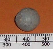
Whilst to the east, various soils were recorded, some containing large quantities of crushed sandstone which might be associated with the wall’s demolition. For the most part, material built up against the eastern side of the wall appeared to be generic garden soil of post-medieval date. The only post-medieval feature of note was a narrow drain filled with horse bone found on the eastern side of the wall. Amongst the finds found within the garden soil was a small lead musket ball, which is thought to be residual evidence of civil war activity from one of the two sieges of Leicester in 1645, the Newarke area being the main focus of attack.

Soil post-dating the destruction of the Newarke Wall dated to the 17th century, but overlying historic Ordnance Survey maps with the results of the project shows that the wall’s alignment remained long after it had been demolished as a boundary dividing properties built on Gray Street to the east and Cardigan Street to the west. This was evident during the excavation, when brick walls of apparent 18th and 19th century construction where found built on top of the medieval wall’s foundation. The wall’s alignment remained until the site was cleared in the 1960s to make way for the Fletcher Building.

One Comment Add yours