We return to the Coventry Charterhouse and in this blog, site director Andrew McLeish takes a look at the (re)excavation of two of the monks’ houses on the eastern range of cells in the summer of 2020 and how archaeology has progressed in forty years.

The title of this particular post I can attribute to one of my lecturers as a postgraduate, although after the best part of the subsequent twenty years’ experience, I (and most other archaeologists) would say “you usually end up with more questions!”…
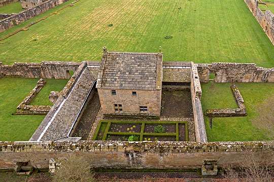
In this instance, our remit was to re-open a previous excavation. In the 1980s the late Margaret Rylatt and her team of volunteers undertook a large scale but partial excavation of the east range of cells, exposing in part four out of the five cells (for reference when we refer to ‘cell’ we are talking about the plot of land each monk lived in which included their house, garden and the enclosing walls.)
Historic Coventry Trust has an ambition to eventually reconstruct two of the monks’ houses, one to show what life was like for a Carthusian monk (currently if you want a taste of it in England you have to go to Mount Grace in Yorkshire where there is a full reconstruction of a monk’s cell) and one specially soundproofed to give visitors an idea of the lack of noise living in a solitary environment in an area without modern noise pollution.
But back to the 1980s… Back then, before the advent of formal guidance on the treatment of archaeology in the planning process (introduced in the 1990s), archaeological excavations were often undertaken at short notice, in what was termed ‘rescue archaeology’, with whatever grant assistance was available, and often with volunteer archaeologists. Margaret Rylatt and her team undertook the excavations of the church at Charterhouse in 1985, and to date the site is the most comprehensively excavated Carthusian church in England, before her attention switched to the eastern range of cells as these were (and still are) the most archaeologically accessible.
Her team uncovered the floorplans of two of the monks’ houses and partially exposed a further two. Drawn and written records were made at the time but this is where time has become a debilitating factor. Nearly forty years have elapsed since those excavations and over the passage of time much of the original documentary archive has been lost, all but one of the original excavation team (at time of writing) has passed away, and surveying and recording techniques have moved on.


So, with the proposed cell reconstruction project we had the opportunity to come back and partially re-open the 1980s excavation footprint as well as extend it to the south and record it with modern survey techniques. But where do we begin?
Before any excavation can commence there has to be a Written Scheme of Investigation (also known as a WSI) which is a document which details exactly where and how the excavation will be undertaken, the image below shows just a small fraction of the document. Because Coventry Charterhouse also has statutory protection as an Ancient Monument, Scheduled Monument Consent also must be obtained from Historic England before any work can commence.
Once the paperwork is in place, the excavation can finally begin! What we are watching in this video is an approximately 2-month excavation compressed down to around a minute. It shows the transition from removing topsoil and overburden with a mechanical digger to hand cleaning the site with the archaeologist classic (some things will, never, ever change!), the 4” pointing trowel, mattock and shovel. Most excavations will remove topsoil and subsoil with a digger but once through that your concentration level goes up as you start looking for changes in colour in the soil, stonework which may turn into walls, signs of old building rubble or darker patches showing posts or pits.
Once the clean-up is done recording can start, nowadays we increasingly use a method known as SfM (Structure from Motion) photogrammetry which uses multiple overlapping photographs stitched together with computer software and tied into the OS national grid with a GPS to give us a highly detailed and accurate 3D model in much less time and with far less error than drawing a scale plan by hand – which we still do for some things.

Using the OS grid points we can now accurately put this model into CAD software to draw a much more detailed plan. However, while all this is visually very attractive, what have we learned from this new excavation?
For starters, the 1980s dig was very well done, though there were some discrepancies with our work – we think the drawings which exist are from the midpoint of the excavation and some internal features recorded were removed subsequently. The main difference that we have found is that the boundary wall between Cells II and III is not where it was traditionally thought to be (and interpreted as such in the 1980s) and as such means part of the Coventry Charterhouse does not fit the layout template for these monasteries in England.
As at least two of our monks’ houses now appear to have been built separate from their plot boundary walls, this of course raises questions about whether the other monks’ houses follow a similar pattern?
We have learned that the remains, whilst looking impressive, are really very fragile and have only a single course or two of remaining masonry where surviving and that the outer wall of Cell II has been partially robbed away leaving only its foundation trench surviving – though this was useful as it gave us a chance to see if there was any sign of earlier structures (which there wasn’t; it looks very likely that our monks’ houses were built from stone right from the start, at the same time as the cloister wall). With Cell II in particular, the 2020 excavation was able to expose the whole footprint of the monk’s house – the 1981 excavation exposed approximately 50 % of the structure with the rest still partly sealed by post med demolition rubble.

We have signs of post dissolution re-use of the structures which fits with anecdotal evidence of them being reused as pig pens. New yard surfaces have been laid with reused stone including sections of worked masonry formerly located in the walls.
Outside the monks’ houses the beginnings of their gardens were identified, some of the pathways uncovered in 2020 were visible in 1981 photographs but were not included on the 1981 plans. Between the post-monastic yard surface and the start of the garden a medieval well also survived in good condition.
Another feature in Cell II has given us a particularly important new piece of information. A feature identified in 1981 as a ‘drain’ was in fact the cut stone recess for a lead water pipe which would have connected to a tap in a specially built niche. This is the first conclusive evidence at Charterhouse for a piped water supply!

From what was seen of the monastic garden features and their level of preservation, the potential survival of the late phase monastic garden presents a fantastic future opportunity for excavation. Neither the 1980s excavations or ours have disturbed much of the area of the garden and as such these deposits could give us the complete footprint of a late Carthusian cell with its house, full boundary walls, covered walkway, latrine, water supply, and full layout of the late monastic phase garden to the point it could be possible to identify outdoor craft and industrial activities, and even the plants grown.
Overall, the eastern range of cells has presented an excellent opportunity to explore the lives of the monastic community, and there is plenty of future potential to keep adding to this story, and to recreate the monks’ homes and gardens. In my next blog I will take a look at the work undertaken in the footprint of the southern range of cells.
