A new student archaeology training excavation in Laughton, Leicestershire has been launched by ULAS and the University of Leicester’s School of Archaeology and Ancient History. The project enables undergraduate students at the University, along with members from local heritage groups, to develop their archaeological skills. The settlement site, discovered only recently in rural Leicestershire, dates to the Roman period (AD 43-410). Project Manager, Dr Gavin Speed, looks at the key findings from the investigation so far.
Background & Project Aims
The Site lies on land to the north-east of the village of Laughton, around 14km south-south-east of Leicester, in the hills along the Northamptonshire border. This is a rural area, with few modern developments, and therefore few archaeological investigations. The Historic Environment Record for Leicestershire and Rutland therefore has very few known heritage discoveries listed in the immediate area.
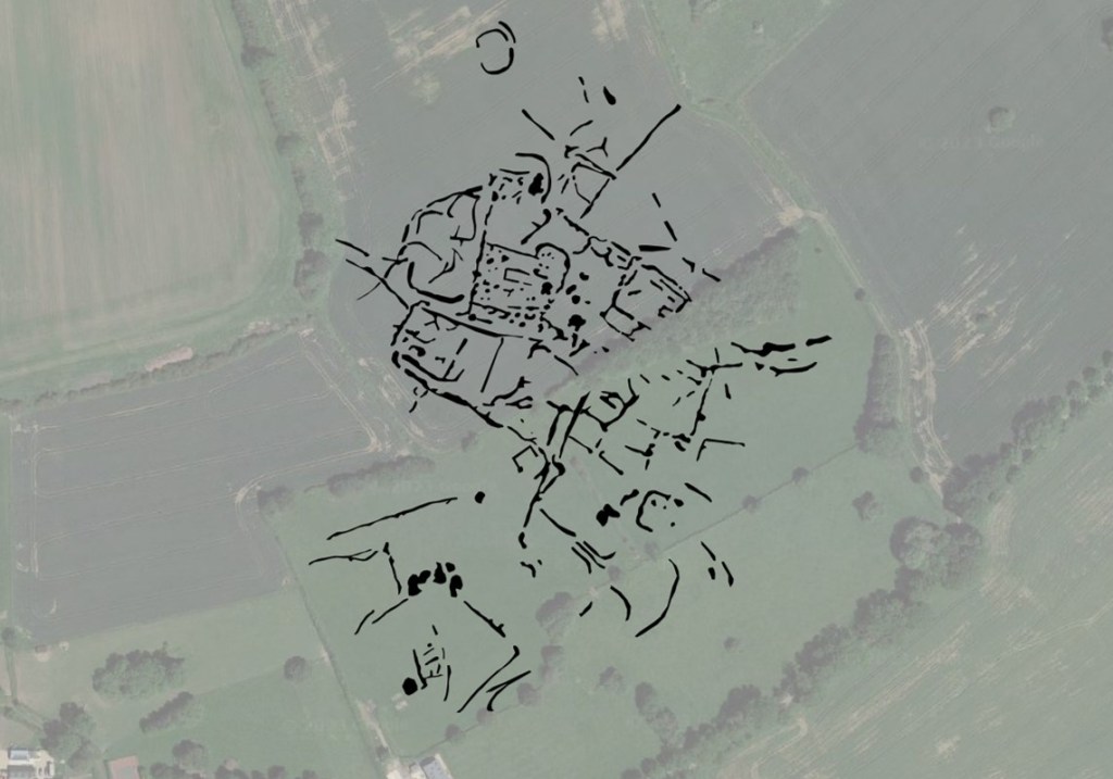
The Site, and surrounding area, was subject to extensive fieldwalking surveys by members of the Oadby and Wigston Fieldwork Group (part of the Leicestershire Fieldworkers), largely from 2019-2022. The results indicated a concentration of Roman finds. The Site was also subject to metal detecting, with Roman and Anglo-Saxon finds discovered. A geophysical survey by the Hallaton Fieldwork Group in 2021 showed extensive geophysical anomalies across the Site, revealing a complex series of inter-connecting ditches, and other features, likely evidence of a Romano-British farmstead. The core of the settlement evidence covers some 3.5ha, with outlying enclosures and ditches covering 8ha. Limited follow up test pitting by the Oadby and Wigston Fieldwork Group in 2021 confirmed the geophysical anomalies as archaeological features of Roman date.
Consequently, the School of Archaeology and Ancient History and ULAS identified the site as a good candidate for a new student field school and volunteer excavation, and in 2023 a training dig was set up to undertake a larger archaeological excavation to try and understand more about the Roman settlement revealed in the earlier archaeological investigations
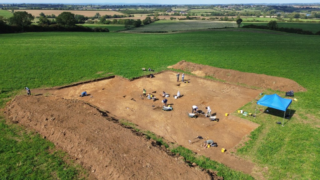
A large trench was opened, targeting some of the archaeological features in the central part of the site where the earlier test pits had indicated the presence of a possible Roman structure within a ditched enclosure.
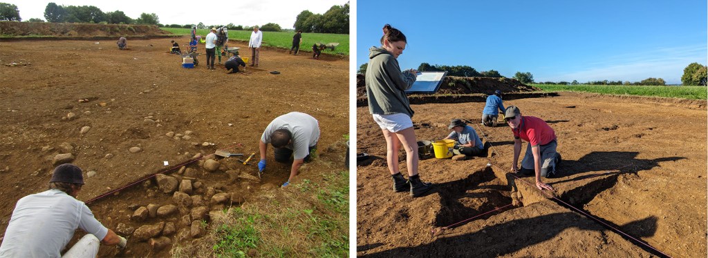
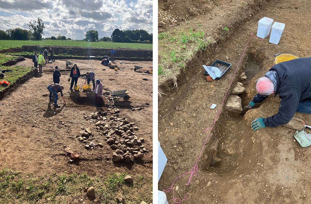
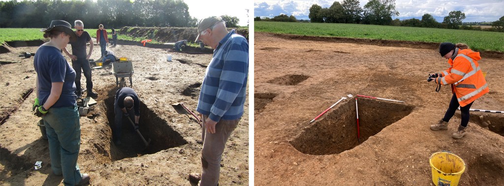
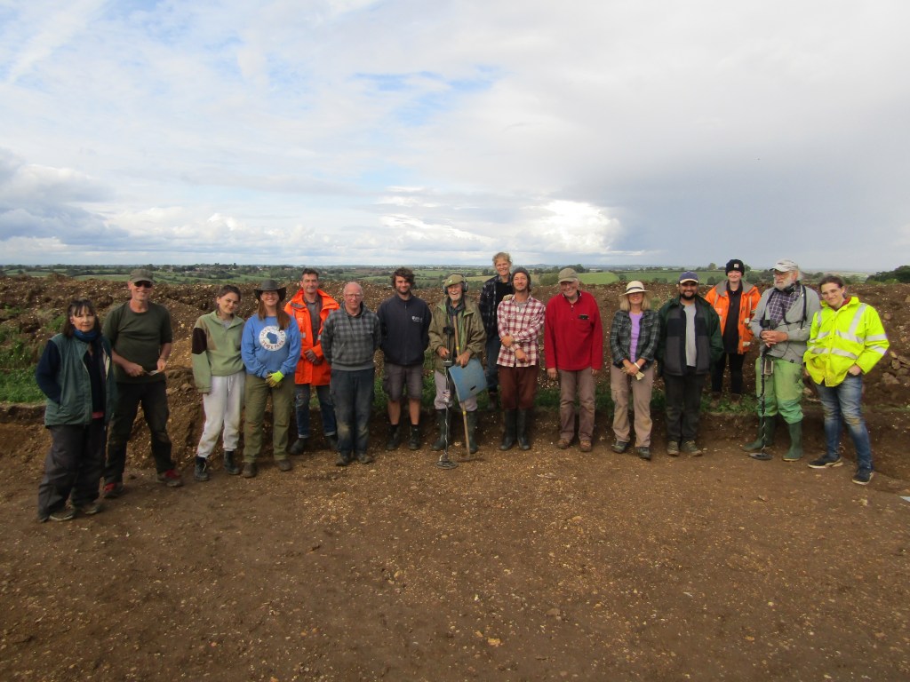
Under the guidance of staff from the School of Archaeology and Ancient History and ULAS, a team of 2nd Year undergraduate students and volunteers from the Leicestershire Fieldworkers embarked on the excavation, and despite the best efforts of some late summer / early autumn rain, produced some fantastic results.
Roman Discoveries
Below the plough soil, evidence for medieval and post-medieval plough furrows were seen across the excavation areas running north-west to south-east, truncating some archaeological deposits. In places these had to be partly removed by hand to expose the archaeological features below.
Earlier prehistoric activity was indicated by a scatter of six struck flints recovered from Roman features. These included a core and a possible scraper but the absence of diagnostic tool-types or technologies in the struck material means that only a broad Prehistoric date can be given, although the generally ad hoc nature of the assemblage could indicate a Bronze Age date. This suggest there was likely low density ‘occasional’ prehistoric activity in the area.
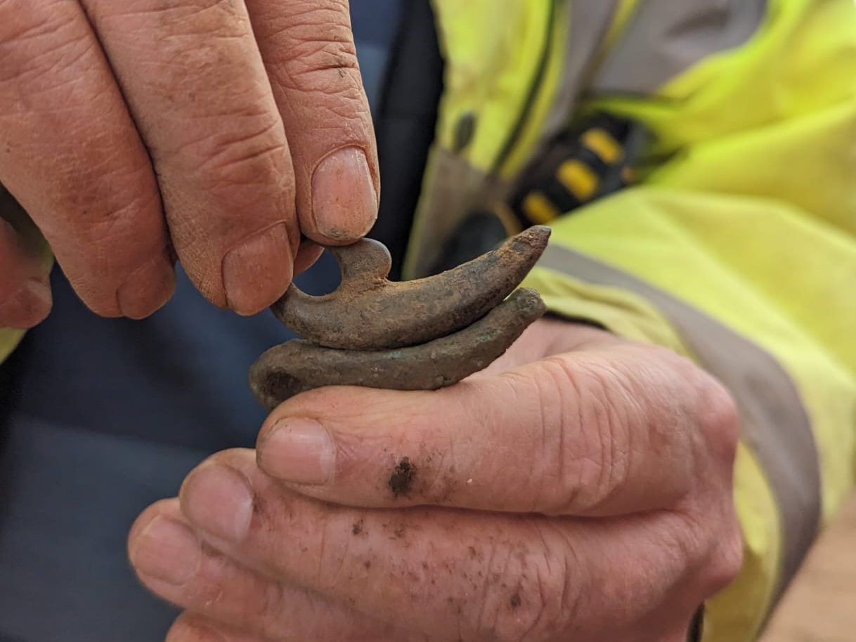
The remains of three Roman enclosure ditches were recorded, appearing to represent at least two phases of activity. Within these were numerous refuse pits and corn dryers. The pottery included both storage vessels and finer table wares dating from the 2nd to 4th centuries AD. Other finds included six coins, all but one appearing to be 4th century, two cosmetic or ‘woad’ grinders, a fragment of shale bracelet and a worked bone pin.
The earliest feature, in the northern half of the excavation, was the south-western part of a ditched, sub-circular Roman enclosure, roughly 18m by 20m in diameter. The enclosure was accessed via a western entrance with most of the enclosure extending beyond the excavation area to the east. The entrance was formed by a pair of termini ditches, with a compacted metalled stone surface within the inner edge. This small enclosure could have been for containing livestock.
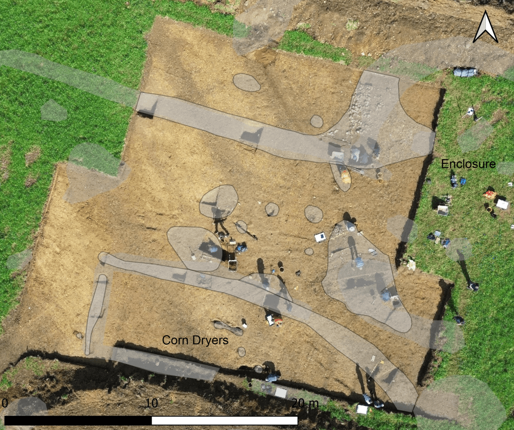
At some point, the enclosure had gone out of use and its ditch was partially backfilled with large stones. Subsequently, a larger and deeper ditch, running east-south-east to west-north-west across the excavation area, was dug. This continued beyond the excavation to the west and terminated to the east. It formed part of a much large sub-rectangular enclosure (perhaps around 40m in length and width) extending to the south and west and visible on the geophysical survey results.
Crop Processing
In the southern half of the excavated area was the northern part of a segmented sub-rectilinear enclosure containing two corn dryers. This had been identified on the geophysical survey and was previously thought to be a structure.
The enclosure measured roughly 17m in length and 5m wide. The western ditch appeared much shallower and irregular in comparison to the northern ditch, perhaps suggesting it formed the remnants of a positive boundary such as a fence or hedge line, rather than a ditched enclosure. Close to it was a small post-hole.
Inside the enclosure, one corn dryer was figure of eight shaped. Scorching of the surrounding soil was noted in the narrow central ‘flue’, suggesting high amounts of heat were generated in this area of the structure. Deposits of malleable yellow clay were also observed, possibly indicating some sort of lining to the structure and a charcoal deposit was recorded at the base of the east end of the feature, likely representing the final use of the corn dryer. Heat cracked stones were also recorded, possibly collapse from a superstructure. Soil samples were taken from the feature and we are awaiting the results from these.
Nearby was a second corn dryer. This appeared deeper at its east and west end, becoming shallower and narrower through its central ‘flue’. Scorching of the soil was again observed in the central area, extending towards the east of the structure indicating high heat processes. Several large sub-rounded limestone blocks were present, concentrated towards the centre of the feature. These again likely represent collapsed superstructure.
Outside the rectangular enclosure, just to the north, was a third corn dryer. This appeared deepest at its south-east end forming a bowl, becoming shallower and narrower through its central ‘flue’ before becoming deeper again at its north-west end. Significant scorching of the surrounding soil was present at its north-west end, suggesting high heat. This extended through the centre of the feature with less scorching present at its south-east end. Deposits of yellow clay, perhaps lining the structure, were again observed.
The presence of three corn dryers in close proximity suggests that this area of the Roman farmstead was used for crop processing. Corn dryers do occur widely throughout Roman Britain, and a recent national study recorded over 350 examples, with most coming from central England. Around 20% from this region come from ‘complex farmsteads’, such as this example at Laughton. Corn dryers were used for processing of cereals, mainly for drying glume wheats prior to de-husking, or to dry grain as part of the malting process. These corn dryers are all of a simple long-hearth single flue form.
Landscape Setting
From the artefacts recovered from the site, the sprawling farmstead was active through the mid to late Roman period, roughly the 2nd to 4th centuries AD. The farmstead sits on an elevated plateau in the landscape, affording expansive views of the valley to the north-west, with the ground sloping steeply down to the north and north west to an area of wetter ground where a natural spring is thought to run, providing access to water.
The presence of Roman activity in the surrounding landscape is minimal, but this is largely due to the absence of archaeological investigations in the area. The position of the site in its landscape is comparable to Roman activity investigated 6.5km east, on the northern fringes of Market Harborough, where a prominent elevated ridgeway appears to be the focus of activity during the Iron Age and Roman periods.
All in all, it has been a very successful first venture onto Top Hold! A big thanks must go to the excavation team who did a great job in often very bad weather conditions and to Tom the landowner who let us dig a big hole in his very picturesque hilltop field. We hope to return for future training excavations, to uncover more of Leicestershire’s rural Roman past.
Learn More
The results from Laughton, are contributing to advancing the research agenda in the East Midlands Archaeological Research Framework (https://researchframeworks.org/emherf/), and the full excavation report will be available on ADS in due course.
To discover more on Roman sites in the region check out some of our books, such as ‘Secrets from the Soil’, ‘Life in the Roman World: Roman Leicester’, and ‘Life in Roman and Medieval Leicester’, available at Shop@le
